Location of underground utility lines
Before the construction work can begin, underground utility lines in the construction area must be located. The goal is to prevent damage to underground utility lines.
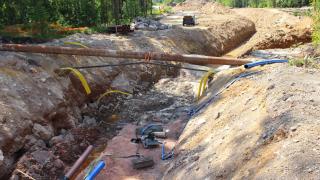
The City of Vantaa builds and maintains streets and other public areas. Management of these areas requires knowledge of the exact location of underground utility lines and related structures. For this purpose, the City of Vantaa maintains an underground utility map.
The underground utility map is based on measured positions of underground utility lines. With the help of the map, all underground utility lines can be located at a later time. The map is used for land use planning as well as for planning municipal technology and different utility line networks.
Underground utility report
An underground utility report must be obtained before performing any excavation, drilling, blasting or other similar activities in a construction area. The report indicates all cables, pipes and other underground structures in the area.
The goal of the report is to prevent damage to underground utility lines during excavation activities.
The underground utility report and related maps are valid for two weeks. The report is for single use and only applies to the construction area indicated by the customer.
In the event of cable damage
In the event of cable damage, please read the General instructions and symbol explanations.
Instructions
Read more
More information
Underground utility report
johtoselvitys@vantaa.fiMore information on the underground utility report